Wednesday, May 28, 2008

Seattle to Montana

Beauty Creek, Idaho
Lake Easton SP, Washington

Seattle to Montana

May 24-28

Saturday: Took the Bainbridge to Seattle Ferry. The ferry ride gave us a nice view of Seattle. Staying at the VASA RV Campground in Bellevue; near Seattle. Chose this campground only because it’s close to Seattle. Very urban setting; noisy & crowded. It has the smallest sites I can recall. Never again. In the afternoon we drove to Marymoor Park. Walked around for a while. It was very crowned being Memorial Day weekend.

Sunday: Drove into Seattle to Pike Street Market. The traffic was light, as expected for a Sunday morning. Found a parking space not far from the market. This place is huge. You name it and it’s fore sale someplace. Lots of weird looking people hanging around. A good place to people watch. We had paid to stay at VASA tonight but disliked the place so much we simply got onto I-90 East and started driving. After an hour of so, we saw a sign for Lake Easton State Park. We went in expecting to see a Campground Full sign. Amazing. They had a cancellation on a site with a partial view of the lake. There is a paved trail leading from the campground to the lake. Let Gopher go swimming. The water was like ice. There is still snow on the surrounding mountain tops.

Monday; Memorial Day: We both like this place so much we decided to stay for two more nights. The best campsite in the campground is #37. As soon as it became clear they people were leaving, we went to the Ranger Station and paid for two nights. This site is huge. Lots of room for Gopher plus an unobstructed view of the lake. Last night while looking at the LD Yahoo! Site, there was a post by a couple from Seattle who wanted to see a new Lazy Daze. We invited them over. Jim & Mary Beth. She’s 5’1” and he’s 6’4”. They wanted to see if he could walk around inside, stand in the shower & fit in the bed. J. They were very pleased with everything. They brought us a bunch of fire wood, some homemade cookies & tuna salad. What a nice surprise. Carol & I enjoyed their company.

Tuesday: Enjoyed a quiet day around this beautiful campground. Took some walks, read our books. The sun came out for most of the day; a pleasant treat.

Wednesday: Heading towards Montana. As you drive east in Washington, you leave the pine forests about in Ellensburg. After that it’s mostly rolling hills and irrigated farms. There was a very interesting sign as we drove through this farming area. It said that for the next 14 miles, signs would tell what crops were growing in that area. What a wonderful idea. Time & again we wished we knew what we were actually looking at. The crops were sweet corn, field corn, peas, potatoes, alfalfa, and wheat. The rest areas all have Wi-Fi; another nice idea. The further east we drove the warmer & sunnier it became. It felt real nice after a month or so in the cool, cloudy coast of CA, OR & WA. About 40 miles west of Spokane the agricultural land uses stop and we get back to the pine trees. In Spokane Valley, just west of Spokane, we made a Wal-Mart run. Ate lunch at the Panda-Panda restaurant. About 3:00 we entered Idaho. Stayed the night at the Beauty Creek FS campground near Coeur D’Alene, ID. Our campsite is right on Beauty Creek. I put my shorts an and Gopher & I went wading in the creek. This is a snow melt fed creek. The water made my feet numb. Even Gopher, who seems immune to the cold, got out after a few minutes. Carol sat in the sun next to the creek enjoying the warmth.

Friday, May 23, 2008

Port Townsend Area

Port Townsend campground.
Point Wilson Lighthouse
Sleeping sea otter

Port Townsend, WA

Tuesday, May 20

In the morning we were still the only people in the campground. While walking the dog, I watched two eagles fishing. By the time I went back for the camera, they were gone. Can’t remember how many times I’ve told myself to always put the camera in my pocket. Left for our next destination; Port Townsend. We’re staying at the Fort Townsend Marina & RV Park. It’s owned by the Port Authority. Our sight is directly on the Admiralty Inlet of the Puget Sound. On the far side of the inlet is Whidbey Island. I chose this park for its location. It’s right downtown near all the historical, shops & restaurants. The Port itself has two restaurants. In spite of the light rain we walked downtown and had a very nice lunch. Carol had a crab/shrimp casserole on an English muffin. I had a fish taco. A very good lunch. After lunch we walked Gopher then stayed inside & read. A cold, gray, misty rain day. For dinner, we had Chinese takeout from the Shanghai Chinese Restaurant which is located about 100’ from our campsite. Another below average meal. It’s hard picking a good restaurant when you’re visiting a town. So far we seem to be batting about 500 on picking restaurants.

I was speaking to a local earlier today. He said they get very little snow or heavy rain around here, but gray & misty is a very typical day. They recently sold their home and live fulltime in a motorhome. Spend the winters in AZ and the summers drifting around here & there. Carol & I agree we would not want to live along the Oregon or Washington coast. It’s beautiful but the weather isn’t very nice much of the time.

Wednesday: Woke up to a gray & drizzly day. Gopher & I walked uptown to an organic bread bakery. We got the worlds best sourdough multi-grain bread. Hot out of the oven. Bought Carol a chocolate croissant as a special treat. We’re both putting on a few pounds from too many “special treats”. Got to stop that. It’s 7pm right now and the bread is over half gone. Once again I left on a walk without the camera. Passed a house with a deer laying down on the grass in the side yard. When we drove into town yesterday we saw two deer walking down the main street. Very strange. Later in the morning, Carol bundled up and we took a nice walk downtown. As the day went on the sun came out on the occasion. Still chilly, but at least it’s sunny & chilly. Now and then Carol ventured outside for a bit. She simply doesn’t like cold weather. Never did but I think her intolerance for cold got worse with the stroke. Earlier in the trip I asked if she would prefer to tour Southern California, Nevada, etc. instead of heading north but she wanted to continue with the original plan.

Thursday Took the dog for an early morning walk downtown. Bought a coffee from a street vendor. Oregon & Washington have lots of drive- up and walk-up espresso & coffee vendors. Later we drove to the good bakery. Carol came with me this time. Bought another loaf of the great bread and Carol got two very large chocolate chip cookies. Our current campground is the Fort Worden State Park in Port Townsend. As the crow flies it’s only a few miles from where we have been. This is a nice place for Carol. Lots of streets & paved walks. Walked to the Point Wilson lighthouse, along the beach path and out on the dock. There is a sea otter living around the dock. The camera wasn’t working well so I couldn’t get good pictures. The sun was out for a few hours today; the warmth felt good.

Friday: After the morning dog walk and breakfast, we walked all around the old fort. Fort Worden was first built because of the Civil War. It was expanded with WW-1 and again with WW-2. We visited the Centennial Rhododendron Garden, saw some of the gun batteries, barracks and officers quarters. The sun was out for the few hours we were walking. Later on the gray skies returned. I was talking to our neighbor in the campground. Mentioned the weather. He just shrugged and said that’s the way it is around here. Any day without heavy rain is a good day. The campground is full; Memorial Day weekend. Families & kids everywhere.
Watched the ship traffic heading out the Strait of Juan De Fuca . Saw three cruise ships heading for Alaska. Tomorrow we head over to Seattle then east to Montana to meet John & Marge on June 1st.

Monday, May 19, 2008

Cape Disappointment to Port Townsend


Cape Disappointment to Port Townsend, WA

Sunday, May 18. Yet another sunny day. Four in a row. We’re headed for the Lake Sylvia SP near Montesano. Drove through the city of Raymond. They had a multi-use trail with metal sculptures all along it. Very pretty. Arrived at the campground shortly after noon time. Lake Sylvia SP is located, as you would imagine, on a lake. Clear, cool water. Our campsite has the best location in the entire campground. Look at the photos. We took a walk around the lake and spend the rest of the afternoon reading and enjoying the view. Talked about what campground had our all time favorite view. A very tough question. We’ve had the good fortune to get some of the best campsites in America. Traveling off season is the key. Here we arrived on a Sunday afternoon. The weekend campers had mostly left and schools not yet out. The best time to snag the prime spots. Memorial Day is this coming weekend. Last week I called about getting reservations at some state parks. Booked as I suspected, so we’re staying in a private campground next weekend.

Monday: Back to our customary weather; cool and overcast. The drive to the Port Townsend area was mostly through pine forests. Stopped at Lake Leland, a county campground. The campground was just OK plus the lake had a warning sign about blue-green algae. Warned that children and pets should stay out of the water because the algae was toxic. We continued to the Lower Oak Bay Campground in Port Ludlum; another Jefferson County park. The campground was very hard to find; there were a few small signs. We got lost for about 30 minutes. I were about to give up when Carol said to turn this way and sure enough, there it was. The campground is very, very basic. It’s on a sand spit going out into Oak Bay. We had the place to ourselves. The view was of the bay on one side and a tidal marsh on the other. We enjoyed it.

Sunday, May 18, 2008

Cape Disappointment WA area


May 16, 2008

Washington.

Cape Disappointment State Park

Another clear & sunny day. Entered Washington at Chinook, on the north side of the Columbia River just across from Astoria, OR. Camped at the Cape Disappointment State Park. This campground isn’t as nearly accessible as Fort Stevens. There was a short path that allowed Carol a view of the river. Gopher & I played on the beach where Carol could watch. We tried a long gravel trail to the ocean but the scooter doesn’t do well in gravel so we turned back. Found a nice viewpoint to park and have lunch.

Saturday: Yet another sunny day. Three in row; a record for the Northern CA & OR part of our trip. We started the day with a trip to the Port of Ilwaco. There is an arts & crafts show on Saturday morning. After that we drove to the city of Long Beach. They have a ½ mile boardwalk that is part of the much longer Discovery Trail. Long Beach itself isn’t much. Your typical summer tourist town. The Discovery Trail follows the original path that Capt. Clark, of Lewis & Clark took along this part of the coast. There are statues & monuments telling of his journey as you walk along the trail. It’s a wonderful paved trail running through the dunes. Later we drove to the far north tip of the Island; Leadbetter Point State Park. On the way back to the campground we stopped at Seaview to walk on the Discovery Trail some more. Much quieter than the Long Beach part. Away from all the tacky tourist parts. Then we did the laundry. Went back to the Port of Ilwaco for dinner. The view from the restaurant was great. We overlooked the harbor and the two tall ships that were in port. The dinner itself, was only fair.

Monday, May 12, 2008

Lincoln City to Astoria, OR


Lincoln City to Astoria.

Heading north on 101. Stopped by a beach area in Pacific city for a rest. Took the Three Capes Scenic drive instead of 101. A much prettier way to travel. Stopped at the Cape Meares Lighthouse. There was an accessible trail to the lighthouse. The three of us enjoyed the walk. Read several informative signs about all the sea birds that live around here. Gopher & I took the dirt trail to the Octopus Tree; a giant sitka spruce tree growing several trunks. (See the photo). We then went to the Tillamook Cheese Factory in Tillamook for a factory tour and cheese sampling. This cheese place is quite famous for its high quality cheddar cheese. Never heard of it but cheese connoisseurs regard it highly. Bought two types; sharp for Carol and garlic/hot pepper for me. Had cheese for lunch and cheeseburgers for dinner. Good cheese but I’m not sure I could tell the difference between Tillamook & Publix cheese. The ice cream they sold was very good. Carol had a scoop of Carmel Pecan, I had Pistachio Pecan. As we were leaving the cheese place, we noticed a lot of police and crowds of people gathering. Asked what was going on. Seems the Oregon presidential primary is soon and Bill Clinton was going to give a speech at the cheese place in about an hour. Having better things to do, we continued on. We camped that night at the Barview Jetty Tillamook County Campground. Took a nice walk to the jetty. Let Gopher run on the beach for a while. There is a very large squirrel that keeps coming around our campsite looking for handouts. If the squirrel gets any closer to Gopher, that’s the end of the squirrel. (See the photo)

Tuesday. Got up about 6am. 50* with a light rain. Took Gopher to the beach for a walk. The plan was to stop at Seaside to walk along the boardwalk. Never stopped raining. Went grocery shopping then to the Fort Stevens SP. It’s 6:30pm now. 50* with a light rain. While walking the dog earlier, I was talking to one of the campground hosts. Mentioned the weather. She just shrugged her shoulders and said “Well, you’re in Oregon”. Reading some Lewis & Clark information. This is the area where they first saw the Pacific Ocean. They stayed in this area for 109 days. It rained for all but 12 of those days. This is the first all day rain we’ve had in the 63 days we’ve been on the road. Can’t complain about that. Carol said time & again how she really likes sunshine. J

Our friends Ted & Liz pulled in late in the day.

Wednesday. Awoke to 50* and rain. About mid-morning we took a drive to see the Columbia River. Found a great spot right on the river. Carol could get a good view and be warm & dry inside the camper. Let Gopher run on the beach.

About noon it started to clear up a little. The sky turned a lighter shade of gray. We drove to the historic part of Fort Stevens. The Fort Stevens Military Reservation guarded the mouth of the Columbia River from the Civil War through WW II. Toured the museum, the old fortifications and some of the grounds. Later in the day the three of us took a long walk to the Coffenbury Lake area. Gopher went swimming. The park has a great selection of paved, multi-use trails. There were a lot of downed trees in the woods and one road was closed. Seems they had a very strong storm in December. Because of all the rain this area gets, the water table is high and trees tend to have a shallow root system. Consequently, strong winds can blow the trees over. Same with the sequoias and redwoods.

On the odd occasion, the sun would come out for a few minutes today.

Thursday; Got up to sunshine and blue skies. First time since we’ve been in Northern California & Oregon. We went into Astoria today. There is a 4 mile paved walkway along the waterfront. We started at the Columbia River Maritime Museum. There were exhibits telling the long history of the Columbia River from ancient times, through Lewis & Clark, and up to the current rescues by the local Coast Guard Station. We thoroughly enjoyed our time here. After that we walked to the downtown area. Had a good lunch. Carol had a fried oyster & bacon sandwich with clam chowder. My lunch was OK; should have gotten what Carol ordered. After lunch we got Gopher and took a long walk to the Port of Astoria; East Mooring Basin. There were dozens of Sea Lions laying on the unused docks. Barking, swimming or just laying in the sun. We saw two eagles sitting on rotted pilings. Waiting to do fishing I suppose. At one time in it’s history, Astoria was a major salmon packing place. There are rotted pilings everywhere from the old over-the-water buildings. Took a picture of the remains of the last of the packing houses. We thoroughly enjoyed Astoria.

Came back to the campground about 3:00. Walked to the lake to let Gopher take a swim.

This is a very nice campground and area. I would certainly recommend it.

Sunday, May 11, 2008

Winchester Bay to Lincoln City, OR


Winchester Bay to Lincoln City

It was 38* & sunny when I got up. This morning we had a bunch of errands to run. Found a Post Office where we Express Mailed Mom some cash and a check. She had called last night to say she was broke. Right across from the PO in Reedsport was The Sugar Shack Bakery. Got a loaf of bread, two hot sticky buns and a Danish. Wonderful. As we were driving out of town we saw deer walking down the street. Carol spotted the 101 Barber Shop in Florence and we both got really short haircuts. Next to the barber shop was a hardware store. I got acetone to clean the super glue off Carol’s glasses that I got on the lenses as I was repairing the frame. Added air to the tires and that was the last of the errands. Had lunch near the Heceta Head Lighthouse.

We stopped at the Cape Perpetua Scenic Area Welcome Center to inquire about accessible trails. There were two. First we did the one mile long Captain Cook Trail “through wind-sculptured vegetation, around Indian shell middens and down to the tide pools”. Carol really enjoyed the walk. Going down to the water was easy enough. Coming up required that I push the scooter from the bottom to the top. Good exercise. The scooter doesn’t have enough power for steep grades. Then we walked the Trail of the Restless Waters. A shorter, but equally beautiful, walk.

Tonight we’re camping in a Forest Service campground; Tillicum Beach. We have a limited ocean view. Our friends Ted & Liz are here as well. Ted took some pictures of us by the motorhome. We rarely get pictures of both of us on trips.

Saturday: Woke up to a misty rain and 47*. The forecast is for this weather to continue today and perhaps tomorrow. Since there were not any good places for Carol to walk, and since it was raining, we decided to continue north. Drove to Seal Rock. Foggy & no seals. Decided to spend the night at South Beach State Park. What a great choice. There are several ADA accessible trails. One leads directly to a large ocean view platform. Gopher & I went walking in the rain. Carol opted to stay warm & dry in the camper. In the afternoon it finally cleared up a little. Like walking through a dense fog. We all took a walk to the South Jetty of the Yaquina River and to the beach overlook. The beach overlook gave Carol a wonderful, unobstructed ocean view. Gopher & I played on the beach right by where Carol was sitting.

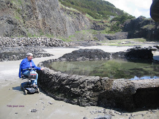
Sunday. Mother’s Day. The sun was out on & off today. We all walked first to the Day Use area, then to the Beach Overlook, then to the South Jetty. At the jetty we saw a replica of an old sailing ship. Let Gopher off her leash at the beach overlook. About 11am we decided to go to the Yaquina Head Outstanding Natural Area located just north of Newport. My research indicated there were accessible trails there. We toured the Visitors Center. Bought Carol a really nice, warm shirt for Mother’s Day. It’s green and says “Yaquina Lighthouse” on the front. We walked to the accessible tide pool area at Quarry Cove. The Bureau of Land Management built these pools as part of restoring the old rock quarry that was here. An excellent place to visit.

Heading north we drove by the D River. The world’s shortest river at something like 120’. It connects Devils Lake with the Pacific Ocean. Drove by Depoe Bay, the world’s smallest harbor.

Crossed the 45th Parallel; midway between the equator and the North Pole.

Continued north planning on spending the night at the Devil’s Lake State Park. We drove through but were not impressed. We saw a sign for the Chinook Winds Casino and headed there. Had their buffet for Mother’s Day then spent the night in the parking lot.

Called Mom. She's doing well. Received the flowers we sent.

Thursday, May 8, 2008

Gold Beach to Winchester Bay


Gold Beach to Winchester Bay

Left our campground on the bank of the Rogue River about 8:30. Overcast & 50*. Drove north on 101 and looked around the very small town of Port Orford. “Port” Orford actually doesn’t have a port. Fishing boats are lifted by a large crane and set on cradles on the pier. See the photo. From there we drove to the Cape Blanco Lighthouse. It was so cold and the wind was blowing so strong that Carol didn’t want to get out. Gopher & I had a nice, but short, walk. Cape Blanco is the westerly most point in the continental U.S. We were at the easternmost point in Lubec, Maine last year. Been to the southernmost in Key West several times. I can’t imagine we’ll ever get to the northernmost point. Continuing our drive up the coast we stopped at the Face Rock Wayside Park. Gopher & I took a nice walk on the beach. Let her off her leash. Drove to the Umpqua Lighthouse. This was the first lighthouse built in Oregon. 1857. We stayed the night at the Winchester Bay RV Resort. It’s owned by the City of Winchester. A very nice place. Clean, riverfront sites, a laundry, & wi-fi. Did four loads of laundry. There is a paved path that runs along the river and around the harbor. It warmed up enough for Carol to join me & Gopher on a walk. Decided to stay tomorrow as well. We met another Lazy Daze couple. Chris & Pam from California. They have been coming north to the Oregon Coast for over 20 years. We had a nice afternoon talking to them.

On Thursday, Chris, Pam , Carol & I, walked into the town of Winchester Bay. It’s just across the harbor from where we’re camped. Had lunch at Kitty’s Kitchen & It’s Christmas Forever Shop. Carol had a turkey/bacon wrap & a huge slice of carrot cake. I had a pastrami sandwich & chocolate cream pie. When we got back to the campground, three other Lazy Daze had pulled in. Ted & Liz from Sturbridge, Mass., Dennis & Penny from Bend, OR and another couple from California. Enjoyed their company.

The sun’s finally out. If the wind would stop it would be a beautiful day. 56*.

Tuesday, May 6, 2008

We're in Oregon


We’re in Oregon. May 6, 2008

Crossed into Oregon about 9:30. Stopped in a Fred Myers store in Brooking. Carol wanted some warm pajamas. While in Fred Myers, Ted & Liz, some Lazy Daze Camping friends we met in Burlington, VT appeared. What a surprise. After that we went to the OR State Visitor Center and came away with a wealth of information. Stopped at a number of overlooks. Spent the night in the Lobster Creek, Forest Service, Campground right on a gravel bar along the Rogue River. The weather is cool, cloudy and misting rain. Except for a nighttime rain in West Texas, this is the first rain we’ve had this trip. Been on the road for 56 days.

Having the most wonderful time.


California Coast

We headed for Eureka, CA via Highways 1 and 101. Hwy 1 runs along the coast line; a beautiful drive with lots of pull-offs. The road was through mountainous terrain. A very narrow and windey road. Lots of hairpin turns. Around Phillipsburg we got off 101 and drove the Avenue of the Giants which took us through several huge redwood groves. Again, there were a lot of picnic areas & pull-offs. We got to Eureka in early afternoon. Went grocery shopping then headed to our camping destination, the Samoa Boat Ramp Campground owned by Humboldt County. This was without doubt, the dirtiest campground we’ve ever seen. Quite a surprise for a County owned facility. We left. Stopped by the “world famous” Samoa Cookhouse. This restaurant has been serving food “lumberjack” style since 1893. “Lumberjack” style means a shared table with food brought out in bowls to be passed around. Much like in Pennsylvania Dutch Country. Tonight’s menu was ham & fried chicken; neither of which Carol wanted so we passed on dinner out tonight. Continued north to the Clam Beach County Park not far north of Eureka. Again a Humboldt County Park. What a pleasant difference. Looks like a campground should. The “campground” is basically a parking lot but it’s right on the dune line. It’s very windy out today. The ocean is rough. Gopher & I took some good beach walks. Since we mostly had the place to ourselves, I took her leash off. It was too cold outside for Carol so she read and looked at the ocean through the windows. Perhaps tomorrow we can find a more sheltered place and Carol can join our walk.

On Monday we continued north on Highway 101 to the Redwood National Park and three California State Parks located between Trinidad and Crescent City. It was cool & foggy when we started our day. First stopped at the Kuchel Visitor Center to inquire about accessible trails. The ranger was very helpful. Our first stop was the Big Tree Wayside. There was a short trail leading to Big Tree; a giant redwood tree. After that we went to the Prairie Creek Visitor Center where there were more accessible trails through the redwood forest. One of these trails was especially nice because it had informative signs along the trail. We continued on and got gas at the Indian Reservation in Klamath. We paid the most we have ever paid for gas. $4.0599/gallon. Off Reservation, gas was going for from $4.099 to $4.129. It cost $192 to fill the tank.

Drove to the Klamath River Overlook but it was so foggy all we saw was fog. We were stopped at the Crescent Beach Overlook, once again fogged in, when an old Class A RV pulled in. The engine was running poorly. The driver kept racing the engine faster & faster and eventually the RV caught on fire!! The driver & passenger got out safely. I called 911 then left fearing the gas tank would blow up. It was a very small overlook with no place to get out of the way if there was an explosion. Saw several police cars, an ambulance and fire truck responding to the 911 call.

In Crescent City we filled up with propane, went grocery shopping, got Carol’s prescription filled at Wal-Mart and washed the RV. It was full of bugs. Our next mission is a haircut for both of us. After doing chores, we camped at the Panther Flat Forest Service Campground east of Crescent City.

Saturday, May 3, 2008

California Coast


Heading for the coast.

Thursday, May 01, 2008

Left Sequoia/Kings Canyon NP about 9:30. Drove to the Dos Reis County Park near Lathrop, just off I-5. Nice place. Perhaps 25 RV sites. Run by the County. This puts us about half way to the coast; our current destination. One strange rule. We were bluntly informed by the matron-in-charge, that dogs must only be on a hand-held 6’ lease. Can’t even tie them to our lawn chair on a 6’ leash. Hand held only!!. They charge $1/night/dog. Does that mean I don’t have to clean up after my dog since I’m paying extra? Oh well. It’s a convenient, one night stop.

Friday: Continued the drive. Had lunch at Granzella’s Deli in Williams. Read about it in one of the tourist books. It’s a local institution. We got there about 11:15. By noon time the place was standing room only. Carol had a turkey/cranberry sauce/cream cheese sandwich. I had a muffalata(sp). Hadn’t had one of those since New Orleans. We drove to the M & M Campground in Clearlake Oaks. An interesting place; not what we had envisioned from the campground book. The campground is at the end of an island. To get there, you drive through an old trailer park. During the day, it’s mostly a local fishing place. When we pulled in there were two other campers. By the end of the day, the place was full. Seems there was a fishing tournament going on. The group next to us must have had ten kids ranging in age from about three to 15. What a mad house. Rap music, screaming kids, etc. Tied Gopher out so we would at least have a little bit of space. Told the kids the dog would bite so stay away. It worked. Carol & I read for the day and I took Gopher for a swim. Tomorrow we will be staying at a state park on the ocean. Yeah!!.

We left M & M campground by about 7:30. Wanted to be out of there before the neighborhood zoo woke up. The drive to the coast was beautiful. Rolling hills, some farms but mostly woods. Fort Bragg is the first city on the coast we came to. Drove a few miles north and camped at the Mackerricher SP. What a beautiful place. After paying for our campsite, we parked right near the beach instead of going to the campsite. Spent the entire day by the beach. There is a handicapped accessible boardwalk leading past the bluffs and intertidal area to the seal watching station. See the great picture of the mother and baby seal. Gopher & I walked the beach at low tide looking in the tidal pools. Carol was able to enjoy the great view with us. I have found a number of accessible sites. Mostly that's where we will be going for the rest of the trip.